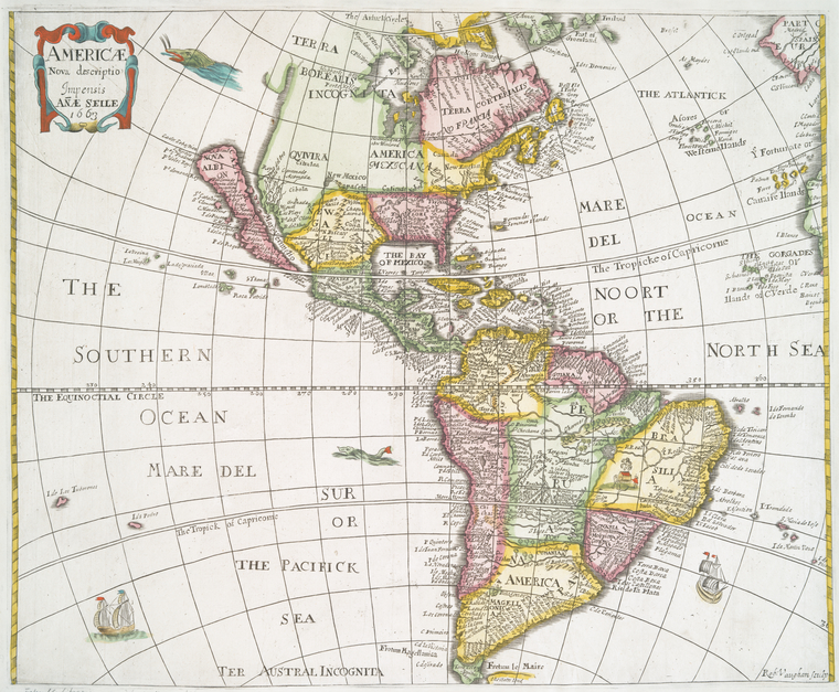
Este mapa conserva la distinción española de Mar del Sur y Mar del Norte para referirse a los océanos Pacífico y Atlántico. En lo que respecta a Bolivia, llama la atención los límites del Perú colonial (Tahuantinsuyo) con Chile.
Toponimia: Charcas, Chichas, Potosí, Porco, Chuquisaca, La Paz, Misque, Cochabamba, Santa Cruz, Moxos; zona costera y puertos de Camarones, Icaife, río Loa, Tarapacá, Mejillones, Morro Moreno, Santa Clara, P. Vela, El Ineal, El Chañaral.
Con respecto al mapa y su autor, la Biblioteca de la Universidad George Washington elabora la siguiente nota contextualizadora para su lectura:
"Henry Seile was a publisher in Fleet Street. He worked on maps for Peter Heylin's "Cosmographie" published in 1652 and later in 1657 (Tooley, 573).
William Trevethen was an engraver. He worked for Heylin and also worked on Roberts "Merchant map of Commerce" (1677) and Mandelso's "East Indies" (1662).
This particular map was first published in Peter Heylin's "Cosmographie." Heylin (a.k.a. Peter Heylyn) (b. 1600) was a Chaplain to the King of England and produced a set of lectures in geography that he first published in 1621 as "Microcosmus" which he later expanded to "Cosmographie." Seile published the maps, engraved by William Trevethen. The maps were a copy of Abraham Goos's map of America (1626), published in John Speed's "Atlas." Evident in this map are a few changes to Goos's original map, including an erasure above Granada and another beneath Cibola. "No. Belgeum" and "Carolina" have been added. It is likely that the term "Carolina" indicates earlier French ownership or exploration of the area as it is too far south for the Carolina region that was to be named in 1660 (Burden, 394, entry 308). The map also shows "Quivira" as north of New Mexico (Wagner, entry 368). The map was published in about five different states. The first is seen here, published in 1652. The later editions were produced from 1663 plates by Seile's widow, Anne. In 1666, a version of the map appeared with the imprint of "Philippi Chetwind" rather than Seile. A fifth state of the map is undated (Burden, 394, entry 308).
Source(s): Burden, Philip D. "The Mapping of North America: A List of Printed Maps 1511-1670." Rickmansworth, England: Raleigh Publications, 1996.
McLaughlin, Glen and Nancy H. Mayo. "The Mapping of California as an Island: An Illustrated Checklist." Saratoga, CA: California Map Society, 1995.
Moreland, Carl and David Bannister. "Antique Maps: A Collector's Handbook." New York: Longman Group, Ltd., 1983.
Tooley, Ronald Vere. "California as an Island: A Geographic Misconception Illustrated by 100 Examples from 1625 to 1770." London: Map Collector's Circle, 1964.
Tooley, Ronald Vere. "Tooley's Dictionary of Mapmakers." Hertfordshire: Map Collector Publications Limited, 1979.
Wagner, Henry R. "The Cartography of the Northwest Coast of America to the year 1800 Volume 2." Berkeley: University of California Press, 1937.
Wheat, Carl I. "Mapping the Transmississippi West." Volume 1. San Francisco: Institute of Historical Cartography, 1957."
Image ID: 1261568
Americæ nova descriptio / impensis Anæ Seile ; Rob. Vaughan sculp. [Americae nova descriptio.] (1663)


No hay comentarios:
Publicar un comentario