Desierto de Atacama
Desierto de Atacama 
Imagen satelital del desierto procedente deNASA World WindLocalización geográfica / administrativa Continente (o sub) Sudamérica País(es)  Chile
ChileCaracterísticas Superficie 105 000 km² Coordenadas 24°30′S 69°15′OCoordenadas: 24°30′S 69°15′O (mapa) Mapa(s) de localización
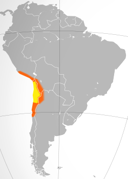 Ubicación del desierto en Sudamérica. En amarillo lo que tradicionalmente se considera Atacama y en naranja otras áreas desérticas colindantes como la cabecera del desierto de Atacama en el sur peruano, el Altiplano andino, la Puna de Atacama y el Norte Chico de Chile.
 [editar datos en Wikidata]
El desierto de Atacama, el más árido del planeta,1 2 3 4 5 se extiende en el Norte Grande de Chile —abarcando las regiones deArica y Parinacota, Tarapacá, Antofagasta y el norte de la región de Atacama— y cubre una superficie de aproximadamente 105 000 km².6 Es de tipo costero frío y está delimitado por el océano Pacífico al oeste y por la cordillera de los Andes al este.
Es una de las ecorregiones de Chile y, además, forma parte de la ecorregión del desierto del Pacífico, que incluye todos los desiertos costeros de Chile y Perú —por su parte, la National Geographic Society considera que la zona costera peruana forma parte del desierto de Atacama—.7 8
Otra parte integrante de este desierto corresponde a una ecorregión denominada puna de Atacama, ubicada sobre los 3500 msnm y que es compartida por la vertiente occidental de la cordillerana de los Andes en el norte de Chile, y por la vertiente oriental de la misma en el noroeste de Argentina y suroeste de Bolivia.
Es rico en recursos minerales metálicos —como cobre (Chile es el mayor productor del mundo y cuenta con el 28 % de las reservas mundiales),9 10 11 hierro, oro y plata— y no metálicos —entre los que destacan importantes depósitos de boro, litio(Chile cuenta con el 39 % de las reservas sudamericanas),12 nitrato de sodio y sales de potasio—. También se destaca labischofita, una sal de magnesio extraída del salar de Atacama, usada como agente apelmazante en la construcción de caminos. Estos recursos son explotados por varias empresas mineras, como Codelco, la mayor compañía cuprífera del planeta,13 Lomas Bayas, Mantos Blancos y Soquimich.
| Desierto de Atacama | ||
|---|---|---|
 Imagen satelital del desierto procedente deNASA World Wind | ||
| Localización geográfica / administrativa | ||
| Continente (o sub) | Sudamérica | |
| País(es) | ||
| Características | ||
| Superficie | 105 000 km² | |
| Coordenadas | 24°30′S 69°15′OCoordenadas: 24°30′S 69°15′O (mapa) | |
| Mapa(s) de localización | ||
 | ||
| [editar datos en Wikidata] | ||

El desierto de Atacama, el más árido del planeta,1 2 3 4 5 se extiende en el Norte Grande de Chile —abarcando las regiones deArica y Parinacota, Tarapacá, Antofagasta y el norte de la región de Atacama— y cubre una superficie de aproximadamente 105 000 km².6 Es de tipo costero frío y está delimitado por el océano Pacífico al oeste y por la cordillera de los Andes al este.
Es una de las ecorregiones de Chile y, además, forma parte de la ecorregión del desierto del Pacífico, que incluye todos los desiertos costeros de Chile y Perú —por su parte, la National Geographic Society considera que la zona costera peruana forma parte del desierto de Atacama—.7 8
Otra parte integrante de este desierto corresponde a una ecorregión denominada puna de Atacama, ubicada sobre los 3500 msnm y que es compartida por la vertiente occidental de la cordillerana de los Andes en el norte de Chile, y por la vertiente oriental de la misma en el noroeste de Argentina y suroeste de Bolivia.
Es rico en recursos minerales metálicos —como cobre (Chile es el mayor productor del mundo y cuenta con el 28 % de las reservas mundiales),9 10 11 hierro, oro y plata— y no metálicos —entre los que destacan importantes depósitos de boro, litio(Chile cuenta con el 39 % de las reservas sudamericanas),12 nitrato de sodio y sales de potasio—. También se destaca labischofita, una sal de magnesio extraída del salar de Atacama, usada como agente apelmazante en la construcción de caminos. Estos recursos son explotados por varias empresas mineras, como Codelco, la mayor compañía cuprífera del planeta,13 Lomas Bayas, Mantos Blancos y Soquimich.
Índice
Origen[editar]
Su origen data de hace unos tres millones de años, siendo en su pasado un lecho marino. Su cambio se relaciona con la llamadacorriente de Humboldt. La principal causa del origen del desierto de Atacama es un fenómeno climático global que, en esta latitud, crea desiertos en las costas occidentales de todos los continentes del hemisferio sur. Grandes sistemas estables de alta presión, conocidos como «anticiclones del Pacífico», se mantienen junto a la costa, creando vientos alisios hacia el este que desplazan las tormentas.
Por otra parte, la corriente de Humboldt transporta agua fría desde la Antártica o Antártida14 hacia el norte a lo largo de las costas chilena y peruana, que enfría las brisas marinas del oeste, reduce la evaporación y crea una inversión térmica —aire frío inmovilizado debajo de una capa de aire tibio—, impidiendo la formación de grandes nubes productoras de lluvias. Toda lahumedad creada progresivamente por estas brisas marinas, se condensa a lo largo de las escarpadas laderas de la cordillera de la Costa que dan hacia el Pacífico, creando ecosistemas costeros altamente endémicos compuestos por cactus, suculentas y otros ejemplares de flora xerófila.
El último factor que contribuye a la formación del desierto es la cordillera de los Andes, que en el norte forma una planicie volcánica elevada y ancha conocida como Altiplano. Así como en el sur la cordillera andina contribuye a capturar la humedad proveniente del Pacífico, en el norte el Altiplano impide el ingreso a Chile de las tormentas cargadas de humedad provenientes de la cuenca amazónica, que se encuentra al noreste.
Clima[editar]
En el desierto de Atacama, una lluvia posible de ser medida —es decir, de 1 mm o más— puede tener lugar una vez cada 15 o 40 años —se han registrado periodos de hasta 400 años sin lluvias en su sector central—.15 Sin embargo, la zona se ve afectada entre enero y febrero por el llamado «invierno altiplánico», que produce alguna que otra lluvia y abundantes tormentas eléctricas. Esta zona registra dos récords meteorológicos mundiales. El primero de ellos es que Aricaanota el promedio anual de lluvias más bajo del mundo, alcanzando tan solo 0,5 mm —la mayor parte de las precipitaciones cae en forma de lloviznas débiles y aisladas—. El segundo es que Iquique registra la sequía más larga del mundo, con 16 años sin precipitaciones.[cita requerida]
En las noches la temperatura influye mucho, pues puede bajar hasta -25 °C en la zona de Ollagüe, mientras que en el día la temperatura se puede situar entre los 25 y los 50 °C a la sombra. No hay mucha diferencia entre el verano y el invierno, porque está situado al límite del trópico de Capricornio. En verano, la temperatura ambiente matinal es de 4 a 10 °C y la máxima puede alcanzar los 45 °C a plena irradiación solar. La radiación solar es muy alta en el espectro ultravioleta, por lo que es indispensable el uso de gafas y cremas con protección UV.
La humedad relativa del aire es de apenas un 18 % en el interior, pero muy alta en el litoral, llegando hasta un 98 % en los meses de invierno. La presión atmosférica es de 1017 milibares. Existen temporadas de vientos en tornado o ventiscas cuya velocidad puede alcanzar fácilmente los 100 km/h, generalmente registrados al mediodía. Latopografía de la zona es de gradiente en descenso muy paulatino hacia el mar, pero su altura promedio relativa es de 400-1500 msnm.
Historia[editar]
El desierto de Atacama ha estado poblado desde los comienzos de la colonización americana. Un hito de los primeros habitantes de esta zona fue la faena minera, que tuvo sus inicios entre 12 000 y 10 000 años atrás en una mina de óxido de hierro en Taltal, Región de Antofagasta, la más antigua del continente.16 17 Durante el periodo prehispánico, descolló la cultura Chinchorro, desarrollada entre 5000 y 1700 a. C.,18 la primera del mundo en momificar artificialmente a sus muertos.19 Además, este territorio fue habitado por etnias como los atacameños, mientras que en su litoral vivían los changos, los coles, los lupacas y los uros. Fue dominado por el señorío de Chucuito bajo el nombre de Colesuyo y luego por el Imperio inca como Collasuyo.
La región más árida fue denominada «despoblado de Atacama» durante la Colonia. Después de las Guerras de independencia hispanoamericanas, y debido a la inexactitud de los documentos reales, la zona estuvo en disputa hasta que, a través de los tratados de límites de 1866 y 1874, la región pasó a ser oficialmente territorio boliviano.
Pese a los tratados suscritos, las disputas no lograron resolverse. El 14 de febrero de 1879, se efectuó el desembarco chileno en Antofagasta, iniciando las acciones militares contra Bolivia. En 1873, se había suscrito el tratado de Alianza Defensiva Perú–Bolivia,20 por lo que Chile declaró la guerra a ambos el 5 de abril de 1879, iniciando formalmente la Guerra del Pacífico,21 que finalizó en 1884 con la victoria de Chile, el tratado de Ancón con Perú y el pacto de Tregua con Bolivia.22 23 Tras el conflicto, Chile obtuvo el dominio del, hasta entonces, departamento boliviano del Litoral y de las provincias peruanas de Tarapacá y Arica.
Deportes en el desierto de Atacama[editar]
El desierto de Atacama acoge a los deportistas del todoterreno del mundo. En este desierto, se han realizado los diversos campeonatos del Rally Baja Atacama, Rally Baja Chile, Rally Patagonia Atacama, y recibió el Rally Dakar Series en 2009, 2010, 2011, 2012, 2013, 2014 y 2015 evento organizado por Amaury Sport Organisation (ASO). Las dunas de este desierto son ideales para este tipo de deporte, ubicadas en los aledaños de la ciudad de Copiapó, Región de Atacama.
Otro evento que se realiza en este desierto es la «Carrera Solar Atacama», que consiste en una carrera de vehículos solares que se hace por lugares del desierto como Toconao, Calama, Iquique y Antofagasta, entre otros.[cita requerida]
Paraíso astronómico[editar]
El desierto de Atacama es considerado uno de los mejores sitios del mundo para observar el firmamento y desarrollar la astronomía: su altura respecto al nivel del mar, la escasanubosidad, la casi inexistente humedad del aire y la lejana contaminación lumínica y radioeléctrica hacen que la visibilidad de su cielo nocturno sea muy nítida. Debido a esto, más de una docena de observatorios se ubica en este desierto —como Paranal (VLT), el complejo astronómico más avanzado y poderoso del planeta,24 ALMA, el mayor proyecto astronómico del mundo,25 26 y La Silla,27 entre otros—. Chile posee el 40 % de la observación astronómica del mundo;28 sin embargo, en las próximas décadas, el sector desarrollará otros proyectos —como el Giant Magellan Telescope,29 el Large Synoptic Survey Telescope (LSST),30 el E-ELT31 y la ampliación del Atacama Large Millimeter Array—32 que harán que el norte del país concentre cerca del 70 % del total mundial.33 Debido a lo anterior, Chile se considera la «capital mundial de la astronomía»34 y se denomina los «ojos del mundo».35
El desierto de Atacama es considerado uno de los mejores sitios del mundo para observar el firmamento y desarrollar la astronomía: su altura respecto al nivel del mar, la escasanubosidad, la casi inexistente humedad del aire y la lejana contaminación lumínica y radioeléctrica hacen que la visibilidad de su cielo nocturno sea muy nítida. Debido a esto, más de una docena de observatorios se ubica en este desierto —como Paranal (VLT), el complejo astronómico más avanzado y poderoso del planeta,24 ALMA, el mayor proyecto astronómico del mundo,25 26 y La Silla,27 entre otros—. Chile posee el 40 % de la observación astronómica del mundo;28 sin embargo, en las próximas décadas, el sector desarrollará otros proyectos —como el Giant Magellan Telescope,29 el Large Synoptic Survey Telescope (LSST),30 el E-ELT31 y la ampliación del Atacama Large Millimeter Array—32 que harán que el norte del país concentre cerca del 70 % del total mundial.33 Debido a lo anterior, Chile se considera la «capital mundial de la astronomía»34 y se denomina los «ojos del mundo».35
Galería[editar]


Véase también[editar]
Referencias[editar]
- ↑ Bolívar Manaut, Luna (27 de noviembre de 2006). «A sobra de sol, buena es el agua»(HTML). www.dw-world.de. Consultado el 22 de julio de 2011.
- ↑ Vesilind, Priit J. (agosto de 2003). «The Driest Place on Earth». National Geographic Magazine (en inglés). Consultado el 2 de enero de 2014.
- ↑ «Driest Place: Atacama Desert, Chile - Even the Driest Place on Earth Has Water»(HTM) (en inglés). www.extremescience.com. 2013. Consultado el 2 de enero de 2014.
- ↑ Mckay, Christopher P. (mayo-junio de 2002). «Two dry for life: the Atacama Desert and Mars» (PDF). AdAstra (en inglés): 30–33. Consultado el 2 de enero de 2014.
- ↑ Amos, Jonathan (8 de diciembre de 2005). «Chile desert's super-dry history» (STM)(en inglés). news.bbc.co.uk. Consultado el 2 de enero de 2014.
- ↑ Wright, John W., ed. (2006). The New York Times Almanac (en inglés). New York, New York: Penguin Books. p. 456. ISBN 9780143038207.
- ↑ Handwerk, Brian (23 de octubre de 2006). «Viking Mission May Have Missed Mars Life, Study Finds» (HTML) (en inglés). news.nationalgeographic.com. Consultado el 2 de julio de 2013.
- ↑ Minnard, Anne (25 de junio de 2007). «Giant Penguins Once Roamed Perú Desert, Fossils Show» (HTML) (en inglés). news.nationalgeographic.com. Consultado el 2 de julio de 2013.
- ↑ Barreno, Jorge (19 de febrero de 2012). «Chile, el mayor productor de cobre del mundo, y el que más reservas tiene» (HTML). www.elmundo.es. Consultado el 3 de julio de 2013.
- ↑ Edelstein, Daniel L. (Enero de 2012). «US Geological Survey: Mineral Commodity Summaries - Copper» (PDF) (en inglés). minerals.usgs.gov. Consultado el 19 de abril de 2012.
- ↑ Toovey, Leia Michele (17 de noviembre de 2010). «The Top 10 Copper Producing Countries» (en inglés). copperinvestingnews.com. Consultado el 18 de abril de 2012.
- ↑ International Lithium Alliance (s/f). «Broad Based Lithium Reserves - South America»(en inglés). www.lithiumalliance.org. Consultado el 10 de diciembre de 2011.
- ↑ Goto, Shihoko (13 de enero de 2012). «Top 10 Copper Producing Companies» (en inglés). copperinvestingnews.com. Consultado el 18 de abril de 2012.
- ↑ Real Academia Española (RAE) (2005). «Diccionario panhispánico de dudas - Antártida». lema.rae.es. Consultado el 16 de febrero de 2013. «Para denominar el conjunto de tierras situado en el polo sur terrestre son válidas las denominacionesAntártida y Antártica. La forma etimológica Antártica [...] es de uso mayoritario en Chile [...]. La forma Antártida [...] es la única usada en España y la preferida en la mayor parte de América».
- ↑ Viajered (28 de noviembre de 2008). «400 años sin lluvia en el desierto de Atacama». viajeschile.es. Consultado el 27 de junio de 2013.
- ↑ Rodríguez, F. (20 de mayo de 2011). «Estudio confirma que mina más antigua de América estuvo en Taltal». La Tercera. p. 52. Consultado el 21 de mayo de 2011.
- ↑ University of Chicago Press Journals (20 de mayo de 2011). «Archaeologists uncover oldest mine in the Americas» (HTML) (en inglés). ScienceNewsline. Consultado el 21 de mayo de 2011.
- ↑ Allison, M. J. et al. (1984). «Chinchorro, momias de preparación complicada: métodos de preparación». Chungará (Arica, Chile) (13): 155–173.
- ↑ Bittman, B., y J. Munizaga (1976). «The Earliest Artificial Mummification in the World? A Study of the Chinchorro Complex in Northern Chile». Folk (en inglés) (18): 61–92.
- ↑ Rawson, Guillermo (27 de septiembre de 1873). «Carta de Guillermo Rawson a Plácido S. de Bustamante después de aprobada en la Cámara de Diputados la adhesión a la Alianza Perú-Bolivia». Consultado el 21 de agosto de 2012.
- ↑ Varigny, Charles (1974). La guerra del Pacífico. Santiago de Chile: Editorial del Pacífico S.A.
- ↑ Villalobos, Sergio (2000). Chile y Perú, la historia que nos une y nos separa. Santiago: Editorial Universitaria.
- ↑ Paz Soldán, Mariano (1904). Narración histórica de la Guerra de Chile contra el Perú y Bolivia. Buenos Aires: Librería e Imprenta de Mayo.
- ↑ European Southern Observatory (ESO) (s/f). «Observatorio Paranal» (PHP). www.eso.cl. Consultado el 4 de diciembre de 2011.
- ↑ European Southern Observatory (ESO) (s/f). «ALMA» (PHP). www.eso.cl. Consultado el 4 de diciembre de 2011.
- ↑ ALMA (s/f). «Atacama Large Millimeter/submillimeter Array». www.almaobservatory.org. Consultado el 4 de diciembre de 2011.
- ↑ European Southern Observatory (ESO) (s/f). «Observatorio La Silla» (PHP). www.eso.cl. Consultado el 4 de diciembre de 2011.
- ↑ Christiansen Z., Axel (12 de junio de 2012). «ESO da luz verde a telescopio más grande del mundo en Chile» (PDF). Consultado el 27 de junio de 2012.
- ↑ «Giant Magellan Telescope» (en inglés). www.gmto.org. Consultado el 4 de diciembre de 2011.
- ↑ «Large Synoptic Survey Telescope» (en inglés). www.lsst.org. Consultado el 4 de diciembre de 2011.
- ↑ European Southern Observatory (ESO). «The European Extremely Large Telescope»(HTML) (en inglés). www.eso.org. Consultado el 4 de diciembre de 2011.
- ↑ «National Radio Astronomy Observatory (NRAO)» (en inglés). www.nrao.edu. Consultado el 4 de diciembre de 2011.
- ↑ Diario Financiero (4 de noviembre de 2013). «Sofofa: inversión en sector astronomía ascenderá a más de US$ 4.400 millones a 2020» (HTML). m.df.cl. Consultado el 26 de noviembre de 2013.
- ↑ «Mandatario entrega terrenos al European Southern Observatory: "Hoy día Chile ya es la capital mundial de la astronomía"» (HTM). www.gob.cl. 27 de octubre de 2013. Consultado el 10 de noviembre de 2013.
- ↑ Espinoza, Cristina (27 de abril de 2010). «Chile tendrá los ojos del mundo» (HTML). www.lanacion.cl. Consultado el 10 de noviembre de 2013.
Bibliografía[editar]
- Braudel, Fernand (1984 [1979]). The Perspective of the World, vol. III de Civilization and Capitalism. ISBN 0-520-08116-1
- Sagaris, Lake (c. 2000). Bone and Dream: Into the World's Driest Desert. 1.ª edición. Toronto: A.A. Knopf Canada. ISBN 0-676-97223-3
- Braudel, Fernand (1984 [1979]). The Perspective of the World, vol. III de Civilization and Capitalism. ISBN 0-520-08116-1
- Sagaris, Lake (c. 2000). Bone and Dream: Into the World's Driest Desert. 1.ª edición. Toronto: A.A. Knopf Canada. ISBN 0-676-97223-3
Enlaces externos[editar]
- El Blog del Desierto de Atacama
- SanPedrodeAtacama.Net & Org
 Wikimedia Commons alberga contenido multimedia sobre Desierto de Atacama.
- Atacama Photo Gallery - imágenes del Desierto de Atacama, paisajes, flora y fauna
- El Blog del Desierto de Atacama
- SanPedrodeAtacama.Net & Org
- Wikimedia Commons alberga contenido multimedia sobre Desierto de Atacama.
- Atacama Photo Gallery - imágenes del Desierto de Atacama, paisajes, flora y fauna
Atacama Desert
From Wikipedia, the free encyclopedia
(Redirected from Atacama)

| Atacama Desert | |
| Desert | |

Atacama by NASA World Wind
| |
| Countries | Chile, Peru, Bolivia, Argentina |
|---|---|
| Area | 105,000 km2 (40,541 sq mi) |
| Biome | Desert |

Map of the Atacama Desert. The area most commonly defined as Atacama is yellow. In orange are the outlying arid areas of south ofPeru, Altiplano, Puna de Atacama and Norte Chico.
| |
"Atacama" redirects here. For other uses, see Atacama (disambiguation).
The Atacama Desert (Spanish: Desierto de Atacama) is a plateau in South America, covering a 1,000-kilometre (600 mi) strip of land on the Pacific coast, west of the Andes mountains. It is the driest non-polar desert in the world.[1][2][3][4] According to estimates the Atacama Desert proper occupies 105,000 square kilometres (41,000 sq mi),[5] or 128,000 square kilometres (49,000 sq mi) if the barren lower slopes of the Andes are included.[6] Most of the desert is composed of stony terrain, salt lakes (salares), sand, and felsic lava that flows towards the Andes.
Contents
[hide]Setting[edit]
The World Wide Fund for Nature defines the Atacama Desert ecoregion as extending from a few kilometers south of the Peru–Chileborder to about 30° south latitude.[7] The National Geographic Society considers the coastal area of southern Peru to be part of the Atacama Desert[8][9] and also includes the deserts south of the Ica Region in Peru.
Peru borders it on the north and the Chilean Matorral ecoregion borders it on the south. To the east lies the less arid Central Andean dry puna ecoregion. The drier portion of this ecoregion is located south of the Loa River between the parallel Sierra Vicuña Mackennaand Cordillera Domeyko. To the north of the Loa lies the Pampa del Tamarugal.
Aridity[edit]

The Atacama Desert is commonly known as the driest place in the world, especially the surroundings of the abandoned Yungay town[10] (inAntofagasta Region, Chile).[11] The average rainfall is about 15 millimetres (0.59 in) per year,[12] although some locations, such as Aricaand Iquique, receive 1 millimetre (0.04 in) to 3 millimetres (0.12 in) in a year.[13] Moreover, some weather stations in the Atacama have never received rain. Periods of up to four years have been registered with no rainfall in the central sector, delimited by the cities of Antofagasta, Calama and Copiapó, in Chile.[1] Evidence suggests that the Atacama may not have had any significant rainfall from 1570 to 1971.[5]
The Atacama Desert may be the oldest desert on earth, and has experienced extreme hyperaridity for at least 3 million years, making it the oldest continuously arid region on earth. The long history of aridity raises the possibility that supergene mineralisation, under the appropriate conditions can form in arid environments, instead of requiring humid conditions.[12] Geological research suggests that in some sections of the Atacama Desert, such as in today's Chile, hyperaridity has persisted for the last 200 million years (since the Triassic).
This desert is so arid that many mountains higher than 6,000 metres (20,000 ft) are completely free of glaciers. Only the highest peaks (such as Ojos del Salado, Monte Pissis, and Llullaillaco) have some permanent snow coverage.
The southern part of the desert, between 25°S to 27°S, may have been glacier-free throughout the Quaternary (including during glaciations), though permafrost extends down to an altitude of 4,400 metres (14,400 ft) and is continuous above 5,600 metres (18,400 ft). Studies by a group of British scientists have suggested that some river beds have been dry for 120,000 years, the same amount as Chad's drought.[14] However, some locations in the Atacama receive a marine fog known locally as the camanchaca, providing sufficient moisture for hypolithic algae, lichens and even some cacti—the genus Copiapoa is notable among these.
Geographically, the aridity of the Atacama is explained by it being situated between two mountain chains (the Andes and the Chilean Coast Range) of sufficient height to prevent moisture advection from either the Pacific or the Atlantic oceans.[15]
Climate[edit]

Although the almost total lack of precipitation is the most prominent characteristic of the Atacama Desert, exceptions may occur. In July 2011, an extreme Antarctic cold front broke through the rain shadow, bringing 80 centimetres (31 in) of snow to the plateau, stranding residents across the region, particularly in Bolivia, where many drivers became stuck in snow drifts and emergency crews became overtaxed with a large number of rescue calls.[17]
This phenomenon is called the altiplano winter, which can produce a little rain and abundant electrical storms, and occurs in January and February.[18] In 2012, the altiplano winter brought floods to San Pedro de Atacama.[19][20]
Comparison to Mars[edit]
In a region about 100 kilometres (60 mi) south of Antofagasta, which averages 3,000 metres (10,000 ft) in height, the soil has been compared to that of Mars. Owing to its otherworldly appearance, the Atacama has been used as a location for filming Mars scenes, most notably in the television series Space Odyssey: Voyage to the Planets.
In 2003, a team of researchers published a report in the journal Science in which they duplicated the tests used by the Viking 1 and Viking 2 Mars landers to detect life, and were unable to detect any signs in Atacama Desert soil in the region of Yungay.[21] The region may be unique on Earth in this regard and is being used by NASA to test instruments for future Mars missions. The team duplicated the Viking tests in Mars-like Earth environments and found that they missed present signs of life in soil samples from Antarctic dry valleys, the Atacama Desert of Chile and Peru, and other locales. However, in 2014, a new hyperarid site was reported, María Elena South, which was much drier than Yungay, and thus, a better Mars-like environment.[22]
Towards Atacama, near the deserted coast, you see a land without men, where there is not a bird, not a beast, nor a tree, nor any vegetation.
“
”
In 2008, the Phoenix Mars Lander detected perchlorates on the surface of Mars at the same site where water was first discovered.[24] Perchlorates are also found in the Atacama and associated nitrate deposits have contained organics, leading to speculation that signs of life on Mars are not incompatible with perchlorates. The Atacama is also a testing site for the NASA-funded Earth-Mars Cave Detection Program.[25]
Valle de la Luna[edit]
The Valle de la Luna in English, the Valley of the Moon, is another area of the Atacama Desert which is said to look like the surface of the moon. It lies 13 kilometres (8 mi) to the west of the town of San Pedro de Atacama.[citation needed]
Flora[edit]

In spite of the geographic and climatic conditions of the desert, a rich variety of flora has evolved here. Over 500 species have been gathered within the border of this desert. These species are characterized by their extraordinary ability to adapt to this extreme environment.[26] Most common species are the herbs and flowers such as thyme, llareta and saltgrass (Distichlis spicata) and, where humidity is sufficient, trees such as the chañar (Geoffroea decorticans), the pimiento tree and the leafy algarrobo (Prosopis chilensis).

The llareta is one of the highest-growing wood species in the world. It is found at altitudes between 3,000 meters (9,842 feet) and 5,000 meters (16,404 feet). Its dense form is similar to a pillow some 3 to 4 meters (10 to 13 feet) thick. It concentrates and retains the heat from the day in order to cope with low evening temperatures. The growth rate of the llareta has been recently estimated at approximately 1.5 centimeters per year, making many llaretas over 3,000 years old. It produces a much-prized resin, which the mining industry once harvested indiscriminately as fuel, making this plant endangered.
The desert is also home to cacti, succulents and other plants that thrive in a dry climate. Cactus species here include the candelabro (Browningia candelaris) and cardon (Echinopsis atacamensis), which can reach a height of 7 meters (23 feet) and a diameter of 70 centimeters (27 inches).
The Atacama Desert flowering (Spanish: Desierto florido) can be seen in years with sufficient precipitation from September to November.
Fauna[edit]

The climate of the Atacama Desert limits the number of animals living permanently in this extreme ecosystem. Some parts of the desert are so arid that no plant or animal life can survive. Outside of these extreme areas, sand-colored grasshoppers blend with pebbles on the desert floor, and beetles and their larvae provide a valuable food source in the lomas. Desert wasps and butterflies can be found during the warm and humid season, especially on the lomas. Red scorpions also live in the desert.

A unique environment is provided by some small hills (lomas), where the fog from the ocean provides enough moisture for seasonal plants and a few animal species. Surprisingly few reptilespecies inhabit the desert and even fewer amphibian species. Chaunus atacamensis, the Vallenar toad or Atacama toad, lives on the lomas, where it lays eggs in permanent ponds or streams.Iguanas and lava lizards inhabit parts of the desert, while salt flat lizards, Liolaemus, live in the dry areas bordering the ocean.[27] One species, Liolaemus fabiani, is endemic to the Salar de Atacama, the Atacama salt flat.[28]
Birds are probably the largest animal group in the Atacama. Humboldt penguins live year-round along the coast, nesting in desert cliffs overlooking the ocean. On salt flats both near the Pacific and inland, Andean flamingos flock to eat algae. Other birds (including species ofhummingbirds and sparrows) visit the lomas seasonally to feed on insects, nectar, seeds and flowers. The lomas help sustain several threatened species, such as the endangered Chilean woodstar.
Because of the desert’s extreme aridity, only a few specially adapted mammal species live in the Atacama, such as Darwin's leaf-eared mouse. The less arid parts of the desert are inhabited by the South American gray fox and the viscacha (a relative of the chinchilla). Larger animals, such as guanacos and vicuñas, graze in areas where grass grows, mainly because it's seasonally irrigated by melted snow. Vicunas need to remain near a steady water supply, while guanacos can roam into more arid areas and survive longer without fresh water. Seals and sea lions often gather along the coast.
Human occupation[edit]

The Atacama is sparsely populated, with most towns located along the Pacific coast.[29] In interior areas, oases and some valleys have been populated for millennia and were the location of the most advanced Pre-Columbian societies found in Chile. These oases have experienced little population growth and urban development. During the 20th century they have had conflicts over water resources with the coastal cities and the mining industry.
San Pedro de Atacama, at about 2,000 metres (7,000 ft) elevation, is like many of the small towns. Before the Inca empire and prior to the arrival of the Spanish, the extremely arid interior was inhabited primarily by the Atacameño tribe. They are noted for building fortified towns called pucarás, one of which is located a few kilometers from San Pedro de Atacama. The town's church was built by the Spanish in 1577.
The coastal cities originated in the 16th, 17th, and 18th centuries during the time of the Spanish Empire, when they emerged as shipping ports for silver produced in Potosí and other mining centers. During the 19th century the desert came under control of Bolivia, Chile, and Peru. With the discovery of sodium nitrate deposits and as a result of unclear borders the area soon became a zone of conflict and resulted in the War of the Pacific. Chile annexed most of the desert, and cities along the coast developed into international ports, hosting many Chilean workers who migrated there.[30][31][32]
With the guano and saltpeter booms of the 19th century the population grew immensely, mostly as a result of immigration from central Chile. In the 20th century the nitrate industry declined and at the same time the largely male population of the desert became increasingly problematic for the Chilean state. Mineworkers and mining companies came into conflict, and protests spread throughout the region.
The Atacama Desert again became a source of wealth from the 1950s onwards, owing to copper mining. The Escondida and Chuquicamata porphyry copper mines are located within the Atacama Desert.
Inhabited towns in the desert include San Pedro de Atacama, Vallenar, and Freirina. In San Pedro de Atacama there is a marketplace for artisanal goods.[33]
Abandoned nitrate mining towns[edit]
Main article: List of saltpeter works in Tarapacá and Antofagasta
The desert has rich deposits of copper and other minerals and the world's largest natural supply of sodium nitrate which was mined on a large scale until the early 1940s. TheAtacama border dispute over these resources between Chile and Bolivia began in the 19th century and resulted in The War in the Pacific.[citation needed]
The desert is littered with approximately 170 abandoned nitrate (or "saltpetre") mining towns, almost all of which were shut down decades after the invention of synthetic nitrate inGermany at the turn of the 20th century (see Haber process).[citation needed] The towns include Chacabuco, Humberstone, Santa Laura, Pedro de Valdivia, Puelma, María Elena, and Oficina Anita.[citation needed]
The Atacama Desert is rich in metallic mineral resources such as copper, gold, silver and iron as well as non metallic minerals including important deposits of boron, lithium, sodium nitrate and potassium salts. The Salar de Atacama is a place where bischofite is extracted.[citation needed] These resources are exploited by various mining companies such as Codelco, Lomas Bayas, Mantos Blancos, and Soquimich.[34][35]
Astronomical observatories[edit]

Because of its high altitude, nearly non-existent cloud cover, dry air, and lack of light pollution and radio interference from the very widely spaced cities, this desert is one of the best places in the world to conduct astronomical observations. The European Southern Observatoryoperates two major observatories in the Atacama:
- The La Silla Observatory
- The Paranal Observatory, which includes the Very Large Telescope
A new radio astronomy telescope, called ALMA, built by Europe, Japan, the United States, Canada and Chile in the Llano de Chajnantor Observatory officially opened on 3 October 2011.[37] A number of radio astronomy projects, such as the CBI, the ASTE and the ACT, among others, have been operating in the Chajnantor area since 1999.
Other uses[edit]
Sports[edit]
The Atacama Desert is popular with all-terrain sports enthusiasts. Various championships have taken place here including the Lower Atacama Rally, Lower Chile Rally, Patagonia-Atacama Rally and the latter Dakar Rally's editions. The rally was were organized by theA.S.O. and held in 2009, 2010, 2011, and 2012. The dunes of the desert are ideal rally races located in the outskirts of the city of Copiapó.[38] The 2013 Dakar 15-Day Rally started on January 5 in Lima Peru, through Chile, Argentina and back to Chile finishing in Santiago.[39] Visitors also use the Atacama Desert sand dunes for Sandboarding (Spanish: duna).
A week-long foot race called the Atacama Crossing is a race in which the competitors cross the various landscapes of the Atacama.[40]
Solar car racing[edit]
Eighteen solar powered cars were displayed in front of the presidential palace (La Moneda) in Santiago in November 2012.[41] The cars were then raced 1,300 kilometres (810 mi) through the desert from 15–19 November 2012.[42]
Tourism[edit]
Most people who go to tour the sites in the desert stay in the town of San Pedro de Atacama.[43] The Atacama Desert is in the top three tourist locations in Chile. The specially commissioned ESO hotel is reserved for astronomers.[44]
El Tatio Geyser[edit]
Main article: El Tatio
There are geysers 80 km from the town of San Pedro de Atacama. There are about 80 geysers that lie in a valley. They are closer to the town of Chiu Chiu.[45]
Termos Baños de Puritama[edit]
Baños de Puritama are rock pools which are 37 miles from the geysers.[46]
Gallery[edit]


.jpg)


Protected areas[edit]
Legends[edit]
See also[edit]
- Puna de Atacama
- Norte Grande, Chile
- 2010 Copiapó mining accident
- Atacama border dispute
- Salar de Atacama
- List of deserts by area
- Llano de Chajnantor Observatory
- Transverse Valleys
- Mano del Desierto
- Pulpería
- The asteroid 18725 Atacama has been named after the Atacama Desert.
References[edit]
Notes[edit]
- ^ a b Vesilind, Priit J. (August 2003). "The Driest Place on Earth". National Geographic Magazine. Retrieved 2 April 2013. (Excerpt)
- ^ "Even the Driest Place on Earth Has Water". Extreme Science. Retrieved 2 April2013.
- ^ Mckay, Christopher P. (May–June 2002). "Two dry for life: the Atacama Desert and Mars". AdAstra: 30–33.
- ^ Jonathan Amos (8 December 2005). "Chile desert's super-dry history". BBC News. Retrieved 29 December 2009.
- ^ a b Wright, John W. (ed.); Editors and reporters of The New York Times (2006). The New York Times Almanac (2007 ed.). New York, New York: Penguin Books. p. 456.ISBN 978-0-14-303820-7.
- ^ Rundel, P.W.; Villagra, P.E. et al. (2007). "Arid and Semi-Arid Ecosystems". In Veblen, Thomas T.; Young, Kenneth R.; Orme, Anthony R. Physical Geography of South America. Oxford University Press. pp. 158–183.
- ^ "Atacama desert". Terrestrial Ecoregions. World Wildlife Fund. Retrieved 11 March2008.
- ^ Handwerk, Brian (23 October 2006). "Viking Mission May Have Missed Mars Life, Study Finds". National Geographic News. National Geographic Society. Retrieved3 April 2013.
- ^ Minard, Anne (25 June 2007). "Giant Penguins Once Roamed Peru, Fossils Show".National Geographic News. National Geographic Society. Retrieved 3 April 2013.
- ^ "Yungay – the driest place in the world". Wondermondo. 3 November 2010. Retrieved3 April 2013.
- ^ Boehm, Richard G.; Armstrong, David G.; Hunkins, Francis P.; Reinhartz, Dennis; Lobrecht, Merry (2005). The World and its People (Teacher's wraparound ed.). New York: Glencoe/McGraw-Hill. p. 276. ISBN 978-0-07-860977-0.
- ^ a b "The desert biome". University of California Museum of Paleontology.
- ^ "Rare snow in the Atacama Desert: Image of the Day". NASA.
- ^ "Chile desert's super-dry history". BBC News. 8 December 2005. Retrieved 25 April2010.
- ^ Veblen, Thomas T., ed. (2007). The Physical Geography of South America. Oxford [u.a.]: Oxford Univ. Press. p. 160. ISBN 978-0-19-531341-3.
- ^ "Snow Comes to the Atacama Desert". ESO. Retrieved 3 April 2013.
- ^ "Hyper-Arid Atacama Desert Hit By Snow". BBC News. 7 July 2011. Archived from the original on 8 July 2011. Retrieved 7 July 2011.
- ^ "The Climate of Chile". This is Chile. Retrieved 3 December 2012.
- ^ "Inundación en San Pedro de Atacama deja 800 afectados y 13 turistas evacuados".El Mostrador (in Spanish). 11 February 2012. Retrieved 3 December 2012.
- ^ "Tourism in San Pedro de Atacama restricted by floods". This is Chile. Retrieved3 December 2012.
- ^ azua-bustos, A. (24 December 2014). "Discovery and microbial content of the driest site of the hyperarid Atacama Desert, Chile.". Environmental Microbiology Reports.
- ^ Braudel, Fernand (1992). The Perspective of the World. Berkeley, CA: University of California Press. p. 388. ISBN 978-0-520-08116-1.
- ^ Thompson, Andrea (5 August 2008). "Scientists Set Record Straight on Martian Salt Find". Space.com. Retrieved 6 August 2008.
- ^ Wynne, J.J.; Cabrol, N.A.; Chong Diaz, G.; Grin, G.A.; Jhabvala, M.D.; Moersch, J.E.; Titus, T.N. Earth–Mars Cave Detection Program Phase 2 – 2008 Atacama Desert Expedition (Report). Retrieved 3 April 2013.
- ^ [cite web=http://www.jstor.org/stable/2475523?seq=3 The Flora of the Desert of Atacama by the Torrey Botanical Club, pages 39-48]
- ^ [cite web=http://animals.pawnation.com/animals-live-atacama-desert-2505.htmlAnimals living in the Atacama Desert on pawnation.com]
- ^ Claudio M. Escobar et al, Chemical Composition of Precloacal Secretions of Two Liolaemus fabiani Populations: Are They Different?, diary of Chemical Ecology, Vol. 29, Issue 3, Mar. 2003, pp. 629.
- ^ South America physical map
- ^ Holsti, K.J. (1997). The State, War, and the State of War. Cambridge [u.a.]: Cambridge Univ. Press. p. 151. ISBN 978-0-521-57790-8.
- ^ Clayton, Lawrence A. (1984). The Bolivarian Nations. The Forum Press. p. 26.ISBN 978-0-88273-603-7.
- ^ St. John, Robert Bruce (1994). The Bolivia-Chile-Peru dispute in the Atacama Desert(Report). International Boundaries Research Unit.
- ^ "San Pedro de Atacama se transforma en una feria gigante". nacion.cl. 16 November 2012. Retrieved 3 December 2012.
- ^ "Exploring the Atacama". yes. Retrieved 2012-12-03.
- ^ Kogel, Jessica Elzea (2006). Kogel, Jessica Elzea; Trivedi, Nikhil; Barker, James; Krukowski, Stanley, ed. Industrial Minerals & Rocks: Commodities, Markets, and Uses(7th ed.). Littleton, Colo.: Society for Mining, Metallurgy, and Exploration. p. 605.ISBN 978-0-87335-233-8.
- ^ "ALMA Upgrade to Image the Event Horizons of Supermassive Black Holes". ESO Anouncement. Retrieved 10 June 2014.
- ^ Toll, Rosser (3 October 2011). "In Chile desert, huge telescope begins galaxy probe". AFP.com. Retrieved $1 $2. Check date values in:
|date=, |accessdate=(help) - ^ "Ruíz-Tagle ve difícil que Chile no esté en un nuevo Dakar". nacion.cl. 21 November 2012. Retrieved 3 December 2012.
- ^ "Dakar Rally event 2013 to culminate in Chilean capital". yes. This is Chile. Retrieved3 December 2012.
- ^ "Atacama Crossing". yes. 4 deserts. Retrieved 3 December. Check date values in:
|accessdate=(help) - ^ "Nueva generación de autos solares son presentados en Chile". nacion.cl. 7 November 2012. Retrieved 3 December 2012.
- ^ "Los autos que competirán en la súper carrera solar de Atacama". nacion.cl. 8 November 2012. Retrieved 3 December 2012.
- ^ "Guide to Atacama Desert". Conde Nast Traveller. Conde Nast. Retrieved 3 April2013.
- ^ Vickers, Graham (2005). 21st Century Hotel. London: Laurence King. p. 122.ISBN 978-1-85669-401-8.
- ^ Erfurt-Cooper, Patricia; Cooper, Malcolm, ed. (2010). Volcano and Geothermal Tourism: Sustainable Geo-resources for Leisure and Recreation. London: Earthscan.ISBN 978-1-84407-870-7.
- ^ Mroue, Haas; Schreck, Kristina; Luongo, Michael (2005). Frommer's Argentina & Chile(3rd ed.). Hoboken, N.J. [u.a.]: Wiley. p. 308. ISBN 978-0-7645-8439-8.
Bibliography[edit]
- Braudel, Fernand (1984) [1979]. The perspective of the world. Civilization and Capitalism 3. Berkeley: University of California Press. ISBN 978-0-520-08116-1. OCLC 505033669.
- Sagaris, Lake (2000). Bone and dream: into the world's driest desert. Toronto: Alfred A. Knopf Canada. ISBN 978-0-676-97223-8. OCLC 57692400.
- Sagaris, Lake. Bone and dream : into the world's driest desert. 1st ed. – Toronto : A.A. Knopf Canada, c2000. ISBN 978-0-676-97223-8
External links[edit]
| Wikimedia Commons has media related to Atacama Desert. |
- "Mars-like Soils in the Atacama Desert, Chile, and the Dry Limit of Microbial Life", NASA press release
- "Roving robot finds desert life", article in Nature
- "A Lady in the Atacama Desert, from the travel blog A Lady in London
- Deatiled article issued by the Geological Society of America on the history of aridity of the Atacama Desert
- Atacama Desert Photo Gallery, photos of many different landscapes and areas of the Atacama Desert
No hay comentarios:
Publicar un comentario